A further extension is, to head south after the Petrol station Drinkstand and follow the river, it will merge into Huangpu River on the way. That is a very interesting part with a lot of river life of people living with and from the waterways. Also some industry. Great cycling, at roads along the river with lots of sharp turns. Good fun if being familiar with the turns and cycling at the personal limit. The different canal variations have already been explained at chapter 3.
4.1 Back north via Songwei Lu
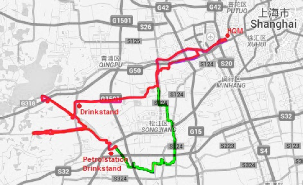
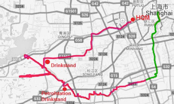
Heading north via songwei lu is reasonable good riding concerning traffic and stops. The green marked part is what changed to the canal rides in chapter 3. Full Canal Songwei.gpx is my personal favorite, which maybe only could be topped by the downtown version.
![]() 4.1.1 Complete Canal Songwei.gpx, Distance: 161km
4.1.1 Complete Canal Songwei.gpx, Distance: 161km
![]() 4.1.2 North leg Canal Songwei.gpx, Distance: 146km
4.1.2 North leg Canal Songwei.gpx, Distance: 146km
![]() 4.1.3 South leg Canal Songwei.gpx, Distance: 143km
4.1.3 South leg Canal Songwei.gpx, Distance: 143km
![]() 4.1.4 Short Canal Songwei.gpx, Distance: 128km
4.1.4 Short Canal Songwei.gpx, Distance: 128km
![]() 4.1.5 Lazy Canal Songwei.gpx, Distance: 123km
4.1.5 Lazy Canal Songwei.gpx, Distance: 123km
4.2 Back north via Humin Lu
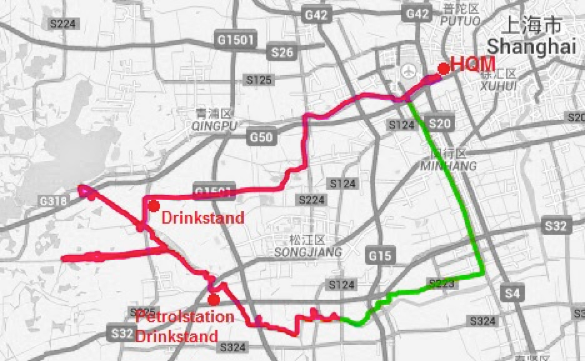
Heading north via humin lu, is terrible riding in my opinion and not to recommend. Many cars, many stops. If a rider found any rhythm at the ride, he definitely will lose it there. Anyhow, I ended up here too often because the further extension at the river is nice. Here, the green marked part is what changed to the “songweirides” at 4.1.
![]() 4.2.1 Complete Canal humin.gpx, Distance: 164km
4.2.1 Complete Canal humin.gpx, Distance: 164km
![]() 4.2.2 Northleg Canal humin.gpx, Distance: 149km
4.2.2 Northleg Canal humin.gpx, Distance: 149km
![]() 4.2.3 Southleg Canal humin.gpx, Distance: 146km
4.2.3 Southleg Canal humin.gpx, Distance: 146km
![]() 4.2.4 Short Canal humin.gpx, Distance: 131km
4.2.4 Short Canal humin.gpx, Distance: 131km
![]() 4.2.5 Lazy Canal humin.gpx, Distance: 126km
4.2.5 Lazy Canal humin.gpx, Distance: 126km
4.3 Back downtown
I never did that variation, but Justin J and Alex D who pioneered that, love it. It will end at the dragon column of Nanbei/Yanan Elevated road.Here, the green marked part is what changed to the “humin rides” at 4.2.
![]() 4.3.1 Complete Canal Downtown.gpx, Distance: 170km
4.3.1 Complete Canal Downtown.gpx, Distance: 170km
![]() 4.3.2 Northleg Canal Downtown.gpx, Distance: 155km
4.3.2 Northleg Canal Downtown.gpx, Distance: 155km
![]() 4.3.3 Southleg Canal Downtown.gpx, Distance: 153km
4.3.3 Southleg Canal Downtown.gpx, Distance: 153km
![]() 4.3.4 Short Canal Downtown.gpx, Distance: 138km
4.3.4 Short Canal Downtown.gpx, Distance: 138km
![]() 4.3.5 Lazy Canal Downtown.gpx, Distance: 132km
4.3.5 Lazy Canal Downtown.gpx, Distance: 132km
Some other options
Normal to drinkstand, then a bit of the lake, then canals, jump over to pudong and oct / vietnam up to fuxing ferry.
A bit shorter option – a different bridge over.
Leave a Reply
You must be logged in to post a comment.